Unesco Route in the Jyväskylä Region
This route comprises two Jyväskylä Region Unesco World Heritage Sites: the Petäjävesi Old Church and the Struve Geodetic Arc. The Petäjävesi Old Church was built by Central Finland peasants in 1763–1765. The Struve Geodetic Arc is a colossal measuring system devised by Friedrich George Wilhelm Struve to experimentally verify the size and shape of the Earth in the 19th century.
This route is created and maintained by the Petäjävesi Old Church Foundation and the National Land Survey of Finland.
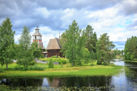
Petäjävesi Old Church
The church is a tale of the everyday lives of the Finnish people over four centuries. The Petäjävesi Old Church was sculpted with breathtaking skill by Central Finland peasants in 1763–1765. When a new church was completed, the old one almost slipped into oblivion in the absence of funds to maintain it. Finally, however, the church was given a new life worthy of its history, perhaps specifically because it had been preserved in its original condition. The church was listed as a World Heritage Site in 1994 as an example of the long tradition of Nordic wooden church architecture. Today, every effort is made to keep the church in pristine condition. This takes money and resources, and some of the costs to do that can be met through an entrance fee. The buildings is very dear to generations of Petäjävesi inhabitants and enchanting to the thousands of visitors it receives every year.
When the Petäjävesi Old Church was completed, Petäjävesi was an out-of-the-way parish, poor and surrounded by untraversed wilderness. The church was designed by the Central Finland church-builder Jaakko Klemetinpoika Leppänen, but its construction and details were entirely local work. The foundations of the church, the joints of the log walls and the shingles of the roof were all laid over one summer, in just 35 days!
The church may be freely photographed. If you share your pictures online, please remember the Petäjävesi Old Church hashtag #petäjävedenvanhakirkko as well as Visit Jyväskylä Region’s #visitjyvaskylaregion
The Church
The pews
People have gathered at Petäjävesi Old Church since the 18th century. In those days, a Mass could take four hours, with plenty of standing throughout the proceedings. With the sermon concluded, the Mass moved on to more secular things with a reading of the “weekly news”, or the public proclamations, which might concern very mundane things, such as a runaway cow. The seating order on the pews was not random: it was custom for men and women to sit on different sides of the church. The north pews were for the women, the south side for the men. Social status also played a role in the seating in the church, in what row and how close to the priest each churchgoer belonged. The church also has a penance stool. Painted black, it was carried out to the aisle for the duration of the service. Those who had transgressed against the community were seated there under judging eyes.
Ceiling/Dome
The church is topped by an eight-sided dome. The shapes and decorative paintings of the ceiling are suggestive of the vaults in stone churches. Jaakko Klemetinpoika Leppänen was a renowned church-builder, but the 12 carpenters working on the construction were evidently skilled as well. Oral tradition claims the church’s chandelier is also a Leppänen design. At dark times of the year, candles in it illuminated the nave.
Pulpit
The pulpit is supported by a bust of Saint Christopher. The use of the saint to carry the pulpit is a visual pun on the name “Christophoros”, meaning “Christ-bearer”. Christopher is less familiar to Finnish Lutherans, but he is well known to Catholics as the patron saint of travellers. On the left of the pulpit stands Jesus, accompanied by two bearded male figures and two crowned women, the furthermost probably the Virgin Mary.
The sacristan’s seat
A sacristan/bell-ringer (lukkari) used to be the only lay churchwarden in many Finnish churches – small ones in particular. Until the early 1800s, their duties might include leading the congregation in hymn, in addition to small tasks such as opening and closing the doors, lighting and extinguishing the candles, and maintaining the liturgical objects. The sacristan also acted as an usher, overseeing the attendance and the proper seating of the congregation. Finally, they might need to intervene if a sleepy attendee should doze off during Mass, using a long ceremonial staff called a verge.
Wine cellar trap door
The church cellar, built originally as a wine cellar in the 1770s, was used for many other purposes, including preservation of the dead in the winter if the earth was too frozen to conduct burials. Only in the spring, when the frost melted, could the departed be laid to final rest in the cemetery. The close presence of death in people’s lives in those days is difficult for the modern observer to comprehend. Finland was a poor country, with significant infant mortality, and everyone was responsible for dressing up their departed close ones for burial.
The Graveyard
Belfry
The belfry flanking the church was built in 1821. It was designed by the grandson of Jaakko Klemetinpoika Leppänen, Eerik Jaakonpoika Leppänen. The belfry acted as a storage building for a variety of items, for which it has four subdivisions: an armoury, the stairwell to the bell tower, a treasury to keep the priest’s alms (i.e. pay), and a mortuary. The belfry also houses the penance stool, the “bench of shame”, to be placed in the middle of the aisle for someone to serve a punishment. The showpiece of the belfry, naturally, are its two bells; the larger one cast in Stockholm in 1781, the smaller one dating from 1903.
The grave of the Ristola children
The influenza pandemic known as the Spanish Flu broke out in the spring of 1918. The virus spread across the globe in a few months, including to Finland and Petäjävesi. The illness proved fatal for so many of the villagers a mass grave had to be dug. Five children from the miller Ristola’s family died of the Spanish Flu. Unusually, the children were buried in the family plot. Some of those buried nearby were from families so impoverished no grave marker could be placed on the resting places of their close ones.
White Guards memorial
Finland gained its independence in 1917. The very next year, a civil war between the Reds and the Whites broke out. The left-wing Red side was made up largely of landless rural people. The White Guards were the forces of the Finnish government. The long-term causes of the war included inequality, particularly the desperate state of the labourers and the crofters.
Grave of Erik Sarava
The oldest marked grave in the churchyard is the tombstone of one Erik Sarava, who passed away in 1837. Any memorial older than this would have been primarily composed of wood, and been lost to decay over the centuries. In those days, a dead body was thoroughly washed and dressed in finery. The deceased would wait for their funeral in a mortuary storehouse at their own farm, until taken to the church by boat or by carriage. Usually, the funerary rites would be given at interment, after which a memorial hymn would be sung.
Cemetery fence
It was important to have a clear barrier between the sacred soil of the church and secular land. It was believed to keep the living and the dead segregated to prevent the souls of the departed from haunting the living. More practically, the fence protected the grave sites from wild animals and grazers.
Petäjävesi
Sheep pastures
In the summer, the meadow next to the church is home to a flock of sheep. The grazing sheep take care of the meadows in the summer, and the guides employed by the Petäjävesi Old Church Foundation look after the sheep. This constitutes an ongoing restoration effort of the surroundings of the Petäjävesi Old Church in order to preserve the cultural environment of the destination. The meadows are part of the World Heritage Site, hearkening back to the nostalgia of Finnish rural life that once surrounded the church.
Lemettilä Farm
Lemettilä Farm, located next door to the Petäjävesi Old Church, has been inhabited since the 17th century. The farm is part of the Unesco World Heritage Site. The municipality of Petäjävesi was founded on this farm in 1868. It originally acted as a sort of a hub for the whole community; for instance, the farm operated an inn from the late 1800s until 1924.
Solikkosaari Island
Solikkosaari Island became the first nature reserve in Petäjävesi in the mid-1970s. The pine woods growing on this long and narrow island were described as scenery that stood out for its natural beauty even at that time. The scenic island, close to the Old Church, was also a popular get-together spot for the village’s children and youth.
The 1879 Petäjävesi Church
When the Old Church was decommissioned in 1879, a new one was constructed on the other side of the island. The old cemetery remained in use, as did the bells of the belfry. The Petäjävesi Church is the third one to be built in Petäjävesi. It was designed by the architect August Boman in a Neo-Gothic style.
Old Vicar’s Manse
The rustic milieu of Tähtiniemi’s former manse includes an impressive old parsonage, a log-built staff dwelling, a large storehouse, an old well, a cellar, a detached sauna, and a gazebo. The Petäjävesi manse was built in 1885 and served as the vicar’s residence and office until the early 21st century.
Struve Geodetic Arc
Welcome to Oravivuori and the Unesco World Heritage Site of the Struve Geodetic Arc. Triangulation and geolocation may not sound too glamorous at first blush, but every accurate map is founded on a modern system of geographic data collection traceable all the way back to the Struve Geodetic Arc. Without survey measurements, we would not know much about our world or the Earth.
The geodetic arc named after Struve today passes through ten countries. 34 of the triangulation points have been selected for preservation as a World Heritage Site, six of which are in Finnish territory. Each country was permitted to pick the most representative destinations for the list. Six Finnish points were selected for listing: Stuorrahanoaivi in Enontekiö (built 1850), Aavasaksa in Ylitornio (1845), Alatornio church (1842), Oravivuori in Jyväskylä (1834), Porlammi in Myrskylä (1833), and Mustaviiri in Pyhtää (1833).
Litter-free destination
Oravivuori is a litter-free destination. No garbage is collected in the area; remove what you brought.
Struve, Friedrich Georg Wilhelm
Struve, Friedrich Georg Wilhelm (b. 15 April 1793 in Altona, Germany, d. 23 November 1864 in Pulkovo, St. Petersburg)
Struve was the outstanding astronomer of his day. Fleeing the Napoleonic Wars to Tartu, he first studied philology, but later transferred to the University of Tartu Observatory, where he became a professor of mathematics and astronomy at the age of 20. Struve never visited Finland personally; his triangulation work was carried out by his trusted subordinate Fredrik Wolstedt. In his final report, Struve recorded the following:
“41. Puolakka, h = 99 toise. A village in the Korpilahti chapel parish under the Jämsä mother parish. Oravivuori hill is located two verst south of this village, a cliff protruding steeply from the shore of Lake Päijänne. On this hill is the station and the point marked with a hole bored in the rock.”
Struve’s point
A tiny point of great significance, a real step towards modern geolocation. Similar triangulation points can be found all the way across the arc. Triangulation was used in surveying to measure very long distances. Triangulation towers were built to enable the next point to be seen at a distance of 20 to 30 kilometres. Triangulation is purely mathematical: when the length of one side of a triangle is known, a distance can be measured through observations of the angles alone, triangle by triangle. Finally came location: the exact position of the point was fixed using celestial references. The fixed position is marked with a cross on the rock and a borehole.
The geodetic arc is composed of 258 main triangles, 265 main points, and 60 secondary points. At the time of its establishment, the arc only passed through Russian and Swedish territory, but today, the points are spread across ten different states: Norway, Sweden, Finland, Russia, Estonia, Latvia, Lithuania, Belarus, Moldova, and Ukraine.
Triangulation tower
With a suitable triangulation site found, a tower had to be built. Using trees felled nearby, with little in the way of equipment, each tower took a week to complete. The erection of the towers to a height of about 40 metres was arduous work requiring considerable skill. Each tower was really two concentric structures. The inner tower contained the measuring instruments, with the sensors located in the external structure. The last triangulation towers were built in the mid-1980s; after that, satellite geolocation rendered them obsolete. The top of the Oravivuori tower is more than 200 metres above sea level. It offers a breathtaking view of the Central Finland lakescape. After sunset, it makes for a great place to observe the stars; in the morning, it is ideal for seeing the sunrise. In fair weather, four other nearby points of the arc can be seen from the tower.
The closest other points:
– Jyväskylä (Roninmäki) 33.0 km
– Rappuvuori 14.0 km
– Vaaterinvuori 28.0 km
– Tammimäki 26.5 km
We remind you Oravivuori is a litter-free destination. No garbage is collected in the area, you should carry out everything you carried in. Because making a fire at the location is prohibited, no camping sausages or similar may be had.
You might also be interested in
Petäjävesi Old Church
Petäjävesi Old Church gained inclusion in Unesco’s world heritage list as an prime example of northern wooden architecture in 1994. The church is representative of Scandinavian, Lutheran church architecture and the long tradition of log building.

Struve Geodetic Arc: Oravivuori Arc Point
Oravivuori arc point is a part of Struve Geodetic Arc. The Struve Geodetic Arc was accepted into the Unesco World Heritage List in 2005. It represents the cultural heritage of science and technology.