Paljaspää
There is one island in Lake Päijänne, a bit further from Jyväskylä than the rest, that stands the tallest. This unusual little island is dotted with high hills in a way that must have been an endless source of inspiration for local artists. And indeed, this is an island on which many artists have lived, including architect Alvar Aalto.
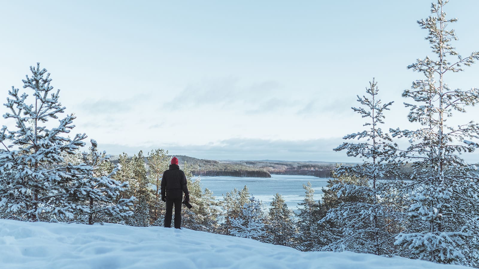
One of the hilltops has become especially important to me. On Paljaspää (Finnish for ‘bare head’), just a few steps will raise you up above a rare landscape that will take your breath away. Paljaspää hill is on the southern end of Muuratsalo island in Jyväskylä. The easiest way to reach the nature trail is by car.
The route to Paljaspää and back is less than 1 km. The terrain is easy, so no need to pack special hiking gear. I would say that the path is suitable even for people with moderate mobility issues, as it is short and not too steep or rocky. The site is a popular place to visit. The track is well beaten even in the winter, so your shoes should stay dry.
Early on, the trail joins a gravel road, so keep your eyes pealed as the nature trail soon forks again out to the left. This is the path that will lead you to the top of Paljaspää. In fact, by now you are nearly there. When the trees start giving way to the sun shining above, you know you are getting close.
Every time I step onto the granite hilltop I feel like I’m somewhere much further away than I really am. Is it the massive rock pushing through the soil that gives me a sense of grounding, and letting my eyes rest on the vast horizon that makes my worldly worries suddenly seem so small. Whatever the magic of the place is, it always gives me a blissful feeling of calm.
The view opens towards the east and over the iconic wide open vista over Lake Päijänne. Seeing the sunrise in the height of the summer – very early! – or on a crisp winter morning are both well worth the effort. The open lake to the northeast, Hauhonselkä, takes several cold winter nights to freeze over. Facing south, an even larger lake area, Ristinselkä, opens up. A view doesn’t get much better than this.
Once you’ve taken in all the beauty you can manage, you can choose any of the many other paths leading from the hilltop. These will take you around the island of Muuratsalo, including the caves of Lullivuori. These paths are not signposted, so if you are planning a longer walk, do bring a map or a GPS device. Muuratsalo island is approximately 5 km long, and the criss-crossing paths may otherwise prove too confusing.
This time I choose to retrace my steps to where I left off, and this is the best part of the Paljaspää trail. It is an easy place to stop at to transport yourself to somewhere far away and back again in no time. It is perfect for a quick coffee picnic or a quick breather in the midst of nature as well as for a full day out.
The nature trail can be found at the end of Vuorelantie. There are two public parking areas near Paljaspää: one at the crossroads of Melalammentie and Kontintie and another near Muuratsalo playground on Vuorenlahdenkatu 38.
This article was produced in collaboration with Retkipaikka and it’s written by Jussi Judin.